condenCITY_58 lines and curves


Rational expressions and organizations, at least in a coherent sense,  as experienced momentarily in Seoul. New commerce rises out of formless city streets. Lines (and the occasional curve) replace the non linear city. While Gangnam can hardly be considered historic by any stretch of the imagination, its roots and side streets retain characteristics of Seoul's urban past. With each new high-rise tower these woven traits of unplanned urbanity slip away. 

Seoul has become linear. 


condenCITY_57 seoul adaptations 1.2


mobile garments_ Seocho-dong 


......[or anywhere]


condenCITY_56 city of refugee


Seoul has been a city of refugee for decades. It's massive growth through the mid-twentieth century was fueled by rural migrations and immigration from abroad. People seeking new opportunity and promotion flocked to the city. Today, Seoul faces a new population of refugees hoping to find political, idealogical and economic freedoms. Ironically, this marginalized population of defecting North Koreans, is given relatively little assistance when faced with issues of housing equality and option. 

This semester, graduate students at Konkuk University will be researching and designing 'transitional' refugee housing for North Korean defectors, to be sited in a quickly changing district within Seoul city boundaries.  A silenced topic (one rarely discussed amongst local design professionals and government collaboration) will be placed at the forefront of discourse with an end of the semester exhibition  of works to be held at Prugio Gallery in Seoul.


condenCITY_55 above


Daum.net aerial view of Ttueksom station in Seoul


Dymaxion Map, Buckminster Fuller, Courtesy wikimedia commons


Now, more than ever, we have access to a myriad of options for viewing the city. Cartography, or the craft of map-making has for centuries been a search for representing the earths surface and its composition in two dimensional form. Maps as two dimensional representations have given way to digitized volumes of aerial shots and three dimensionally charted land/ building forms, capturing nearly every corner of our urban (and rural) environments. It seems impossible that the two dimensional map, be it analogue or digital, will disappear anytime soon. The ability to view the city or any arrangement on the earths surface from various vantage points in nearly live time, has been augmented with combined technologies for unprecedented realism in viewing the composition of the earths surface from above.    

By comparison, the Dymaxion map, patented by Buckminster Fuller in 1946, was a projection of a world map onto the surface of a polyhedron. The ensuing pattern was then unfolded using various methods and flattened to form a two-dimensional map which, in the end retained much of the proportional integrity of the globe map. While it may seem easy to dismiss the accuracy of the Dymaxion map at first glance, when in fact it is the deception of our minds eye that challenges relationships of the continents we have come to recognize in a northerly upward orientation, form and arrangement. The polyhedron superimposed grid establishing accurate break points, while maintaining continental precision. 

So too, is the current aerial deceptive in its momentary, time captured snapshot of the city. Here today, and as is the case in Seoul, altered city tomorrow. Perhaps in the near future technology will have bridged the gap between transforming cities/ land forms and the digitized lenses through which we view them. 


condenCITY_54 urban gaps


The city of Seoul is always in-between, both physically and metaphysically. The gaps and fissures that feed our imagination are voids for intervention. They expose the tattered form of transformation caught between yesterday, today and tomorrow. Time is presented as exposed fragments; weathered and aged, testament to the labored roots of a cities humble beginning. 

Early autumn brilliant blue breaks the hazy grey of thick summer. With mid-summer weight lifted the urban gap is once again free to breath.


condenCITY_53 seoul adaptations 1.1


His divided life, halved by structures before him that cast dark midday shadows. The other side of the road a world apart. He catch glimpses of through sluggish, unending traffic and towering concrete columns to another world. This industrial city, where workers ceaselessly tire from sun up till evening, the air tinged thick with the smells of determined labor. On a bright summers day it stifles the senses. This is the workers city, built on hand and foot with stern faces. 

My life on the same metro-line, a minutes journey away and yet a social-political world apart. My train glides past above looking down at the city floor below. Speculations and ruminating on an adaptable city. 


Cal Berkeley Architecture: The First 100 Years


There was a time from 1999 to 2003 when Wurster Hall was mostly closed for seismic renovations. I say mostly because a few rooms on the lower non-studio corridors remained open for classes. I was at Berkeley during this strange transitional time. Reflecting back, it seemed disappointing then to have not been a part of Wurster's long history but our class and the others around ours had a history of its own perhaps part of the uniqueness of a Berkeley education (and the departments relatively long history in American Architecture education). 

A recent article and good read at the Architects Newspaper highlights the last 100 years of the College of Architecture at UC Berkeley. With fondness those of us remembering the voices and spaces that shaped our formative years- and still forming to this day.


condenCITY_52 tattered edges


Gwangju in the far south on the Korean peninsula is a city seeking identity. In recent years its outwardly expansive growth has sought to create a new urban center for business, residence as well as renewed image for the city in general. This growth to the western urban edge has now joined efforts with the Korean governments recent campaign to redevelop the four major rivers throughout the country. Political argument has it that redeveloping the river corridors will attract tourism and protect urban areas from flooding. Read more on the history of the projects here at the Joongang Daily. 

Whats most shocking is the processional erasure of natural habitat presently being bulldozed in the name of 'restoration'. Design and development needs to have its limits (if this can even be classified as design). The river corridors are home and habitat to migratory Egrets and various other species now threatened by habitat destruction. The natural 'design' of such places should remain just that. No amount of beautification can claim progress over what nature can accomplish rightly on its own; and the projects are just that unsightly beautification.


Un-condensed rural 1.0


I'm not going to use the words 'green' or 'sustainable'. Truly we have always know of these ideas, lived them to a larger extent (in many cultures around the world) without the commercialized use of these terms, without the "greening" of anything. So how have we forgotten about these basics of life? How have we forgotten what it means to be a part of our environment so seamlessly? These are fundamental questions that seem easily exposed when visiting places inherently part of a larger system. 

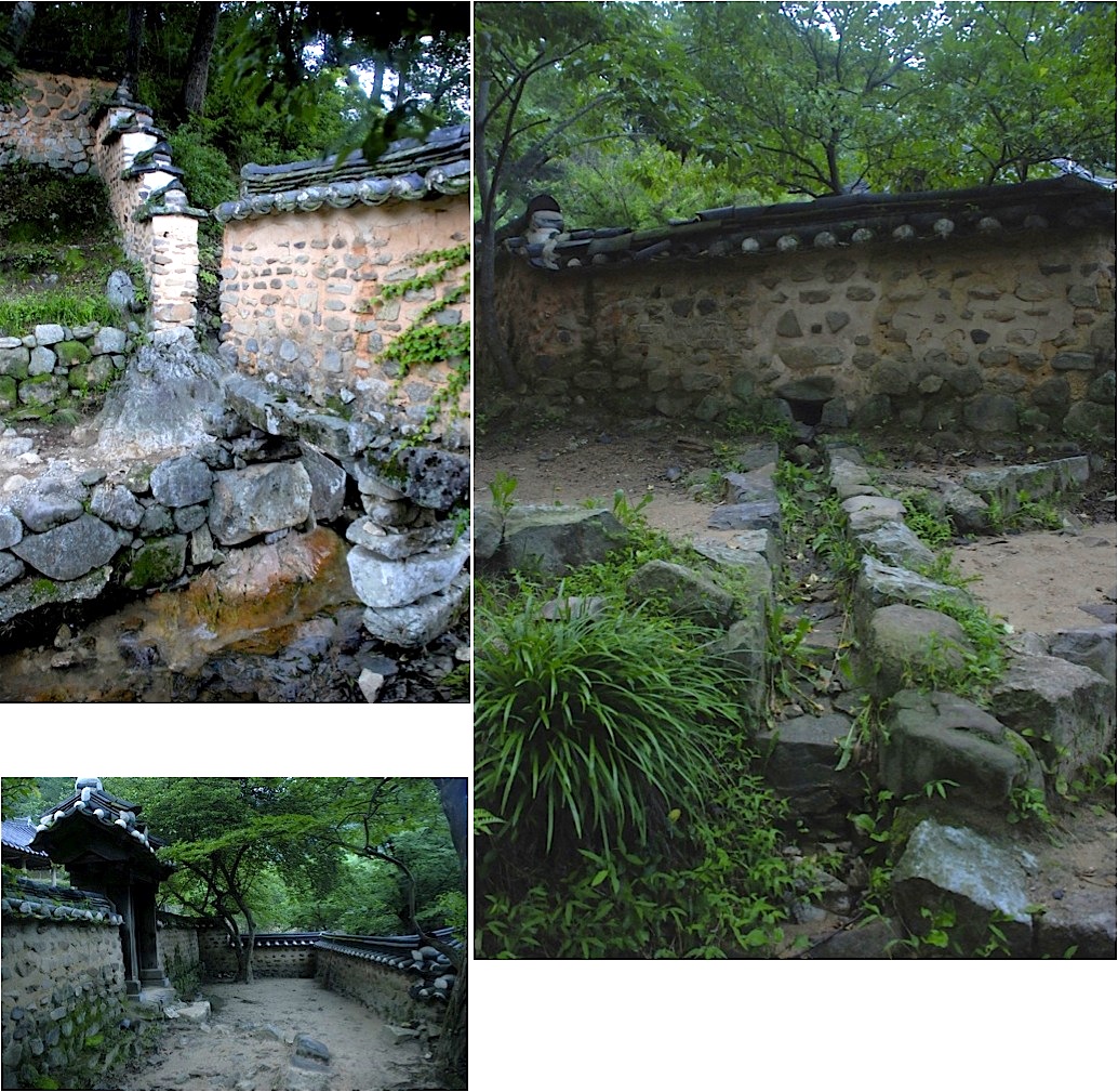
I recently revisited a historic garden in the far south on the Korean peninsula. Maintained for over five hundred years, Soswaewon has passed through successive generations as a place of seclusion, meditation and scholarly discourse. It has passed through the hands of political outcasts, scholars, invading governments (Japan) and was subsequently rebuilt after Colonial destruction.  In Korea, it is one of the most recognized historical places of its kind and continues to represent uncompromising points of view regarding 'constructing' in the context of nature. Balance has been established through relationships. 

Soswaewon is composed of a meandering wall which, encloses the garden on all sides except to the southeast where the site is bound by a small creek. The wall shifts from edge boundary to internal divisor and in doing so separates a small structure (a residence of the host) situated at the highest elevation in the garden. An even smaller residence for a guest placed at the lowest elevation just below the hosts house.  At the middle of the garden the wall encloses a small outdoor space of meditation, or what one can assume was the past function of this 'outdoor room'. The wall continues to transform over the restricted distance of the valleys shifting topography, giving way to altered functions. The wall rises and falls, responding to both nature and human necessity.  Its function oscillating between boundary and permeability, being seen and being invisible, exposing and concealing. The expression of which is a clear reflection of a balanced existence. 


condenCITY_51 lost city


 Namdaemoon destruction and reconstruction: images courtesy Chosun Ilbo

Just over two years ago an arsonist set fire to Sungnyemun on Feb. 11, 2008. Korea's No. 1 national treasure was burned with almost 70% (as reported in the news) total destructive damage to original wood structure with the entire second level of the ancient city gate known as Namdaemun being destroyed. Sungnyemun was originally constructed in 1396. The reconstructive efforts have exposed newly unearthed original foundation stones dating back to the early period of the Joseon Dynasty.

The newly discovered foundations have also revealed discrepancies in what was thought to be the original elevation of the old city gate. Excavation experts have noted that the current ground level around the historic structure is approximately 1.4 meters higher than the orginal ground elevation, obscuring the original foundation stones. As reported researches will now document the gates height at 8 meters obove sea level.